Post-Dispatch metro columnist Tony Messenger discusses his series of columns about a project to move a levee in Atchison County away from the Missouri River and interviews a local farmer about how it happened.
Editor’s note: This is the first of three columns about a levee setback project that could be a turning point in Missouri River policy in the face of climate change.
ROCK PORT, Mo. — Clouds of thick, brown dust trail the tractors and combines working the fields in late April along Interstate 29 in far northwest Missouri.
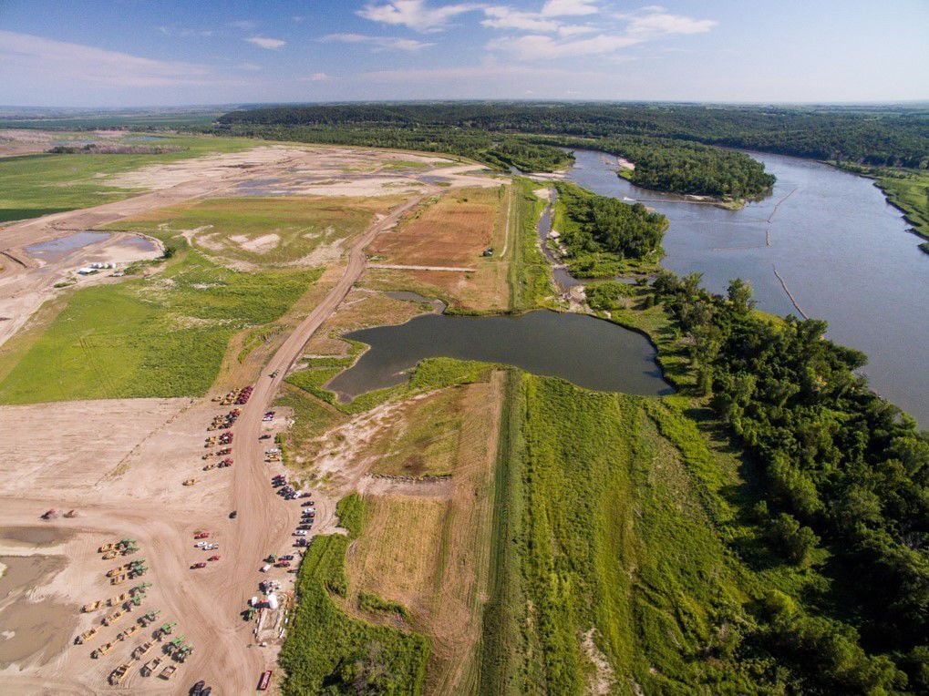
It’s planting season, with soybeans and corn going into the ground, and local farmers hoping the weather allows high yields from the rich bottomland soil near the Missouri River. Not far from the banks of that river, west of the interstate, there is a different kind of work taking place.
Dozens of massive ground-movers, bulldozers and tractors are scraping, digging and carrying sand, dirt and clay from more than 1,000 acres near the river and moving it back to rebuild .
People are also reading…
For decades along the banks of the river, in Missouri, Iowa, Nebraska and the Dakotas, this has been the pattern after a season of floods. Massive flows of water break through or top levees meant to protect agricultural land, rural towns or even metropolitan areas. Levee districts made up of local landowners and farmers — and the Army Corps of Engineers if it’s a federal levee — rush to rebuild before the next flood, sometimes raising the levee to offer more protection.
So it was in 1943, 1952, 1967, 1978 and 1993. Since that most famous of the “Great Floods,” there have been more, coming more regularly with climate change: in 2011 and again in 2019.
For the folks in Atchison County, the latest flood two years ago might have been the worst of all. And it is producing a solution different from every other time the levee was breached and damaged.
This time, they are moving the levee back and giving the river more room to roam. It’s hard to put into words how remarkable and potentially historic this development is. For some of us, it would seem simple common sense: If a levee meant to protect farmland and an interstate highway keeps getting overtopped by more frequent and severe floods, doesn’t moving it back make sense?
Of course it does. And it’s been the model pushed by scientists and river experts for more than a century. But generally, that’s not what has happened, either with this levee nor the thousands of others up and down the Missouri River in the 10 states that make up the basin.
Richard Oswald is a veteran of decades of those river battles. A fifth-generation farmer in Atchison County, he has long been a lonely voice among those of his livelihood, lamenting the inability of various interest groups along the river to work together to manage flooding. Oswald and I first talked in 2011, at the time one of the worst floods he had seen. It closed portions of I-29 for weeks, shutting down commerce and causing massive damage to local farms.
For Oswald, and most of his neighbors, 2019 was even worse. His family’s historic farmhouse, first flooded in 1952, became no longer inhabitable. He built a new home after months away from his farm, waiting for the water to recede.
The 2019 flood was so bad that minds in the region started to change about how to respond.
Normally, some version of the same old fights play out after a flood:
• Farmers blame the Corps of Engineers for releasing too much water from upstream dams, built after the 1943 flood as part of the Pick-Sloan Plan.
• The Corps blames the master plan devised in congressional compromise for forcing its hand.
• Northern states blame southern states for requiring certain water flows for navigation on the river.
• Southern states blame northern states like the Dakotas for hoarding water for recreation.
• Everybody blames environmentalists for caring about two birds (the piping plover and the least tern) and a fish (the pallid sturgeon), whose habitats must be protected according to the U.S. Fish and Wildlife Service.
This time, things are different. Environmentalists from are guiding the process as conveners, getting everybody to the table and keeping them on task. The Corps and the farmers and the local levee district are getting along. Everybody agrees that moving the levee back is the best thing for local landowners, for the Missouri economy and the future of the Missouri River.
“At some point, you just have to acknowledge that what we were doing doesn’t work,” Oswald says. “We have to do something different.”
In northwest Missouri, debates on flood policy center on farming. In ◊Ó–¬–”∞…‘≠¥¥, the focus is development in the flood plain, like the ongoing debate over Maryland Heights‚Äô plans to build a commercial district inside the Howard Bend Levee. The bottom line is the same: The river needs room to roam.
The Atchison County levee setback project has the potential to become a national model for future river policy. “That’s what’s going to have to happen,” Oswald says. “There’s no way to control the river.”
Coming Sunday: Historic levee setback takes shape.
Coming Monday: The view from ◊Ó–¬–”∞…‘≠¥¥.


